r/geography • u/LeaveMeAloneAdmins88 • 11d ago
Map What parts of the world look like unrealistic fantasy maps?
12.0k
Upvotes
r/geography • u/LeaveMeAloneAdmins88 • 11d ago
r/geography • u/bookflow • Nov 06 '25
r/geography • u/Emotional-Move-1833 • Sep 03 '26
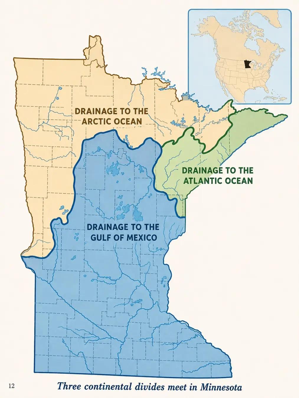
A single point in Minnesota, USA called the Hill of Three Waters near Hibbing splits rain into three different major water bodies in three different directions: south to the Gulf via the Mississippi, northeast to the Atlantic via Lake Superior, and northwest to Hudson Bay via the Red River (yes, some Minnesota rivers flow north, a legacy of glacial Lake Agassiz). One of the flattest states around, somehow feeding into water bodies in 3 totally different directions.
r/geography • u/cavaismylife • Mar 23 '26
r/geography • u/Ganyu_Yeyang • Aug 26 '26
28°17'31.65"N, 85°31'25.04"E
r/geography • u/FunForm1981 • Aug 09 '25
r/geography • u/AltruisticSquare7304 • Jun 04 '26
my favorite things was seeing union of soviet socialist republic and yugoslavia lmaoo
r/geography • u/urmummygae42069 • Jul 21 '26
If you were to divide California into 4 roughly equal strips of area, a hefty majority of its 39 million residents live in the southernmost strip containing the LA+San Diego metro areas, with nearly half of the state (~47%) living in the Greater LA metro area alone. If it were its own state, Southern California, with primarily just LA and San Diego metro areas, would compete with Florida for title of 2nd most populous US state.
The SF Bay Area, Sacramento, Monterrey, Fresno, and most of the Central Valley and put together are short of SoCal by over 9 million residents, but on its own this area would compete with Illinois for title of 6th largest state.
The strip sandwiched between Southern California and the Bay Area, containing Bakersfield plus other farming towns in the Southern Central Valley and most of the towns of the Central Coast, has about more people than Utah or Connecticut.
Suprisingly, despite how empty it can feel, there are still over a million people still live in the strip of CA north of Sacramento, containing about as much people as Hawaii and New Hampshire, albeit of a larger area.
Ultimately, one way to better understand the scale and density of California, is to conceptualize it as Florida + Illinois + Utah + Hawaii, all packaged in one single state under one single state government
r/geography • u/One-Seat-4600 • Jul 20 '26
r/geography • u/Forward-Many-4842 • Jun 14 '25
r/geography • u/Dumbledore27 • Aug 29 '25
Had
r/geography • u/Flaimzy_01 • Sep 12 '26
I saw some latitude maps the other day and noticed that they placed USA slightly more south than it was since it didn’t overlap with Poland even though Poland is about 15 miles into where the USA upper border is with Canada
r/geography • u/CarpenterFrequent744 • Nov 30 '25
r/geography • u/KindMouse2274 • 13d ago
No major roads for miles, Very little population, And the tri-state border is rarely visited. I can only find a handful of photos of it online.
r/geography • u/GargantaProfunda • Aug 06 '25
r/geography • u/Electronic-Koala1282 • Feb 28 '25
r/geography • u/Top_Drop_6288 • Dec 15 '24
r/geography • u/Similar_Whole5626 • Jul 16 '26
r/geography • u/Neither-Mention7740 • Aug 12 '25
A bridge here could mean someone from one side could go drive to the other side without having to go through Melbourne.
r/geography • u/Just__Touch__It • Jul 14 '26
r/geography • u/RatioScripta • Jul 13 '26
r/geography • u/reallinguy • Jun 13 '25
r/geography • u/One-Seat-4600 • May 28 '26