r/geography • • Sep 12 '26

META r/geography Census Results (Section 1)

Thumbnail
gallery
98 Upvotes

r/geography • • 12h ago

Map The density of Sugar Maples almost exactly lines up with the places that are commonly said to have the best fall colors

Post image
1.7k Upvotes

The Upper Pensula and Northwoods, Adirondacks and northern New England, the Ohio valley and Appalachia. All of these places are commonly said to have the best fall colors in the country, and those regions are also where the highest density of sugar maples are.

One of the best trees in the world, simply stunning in fall.


r/geography • • 7h ago

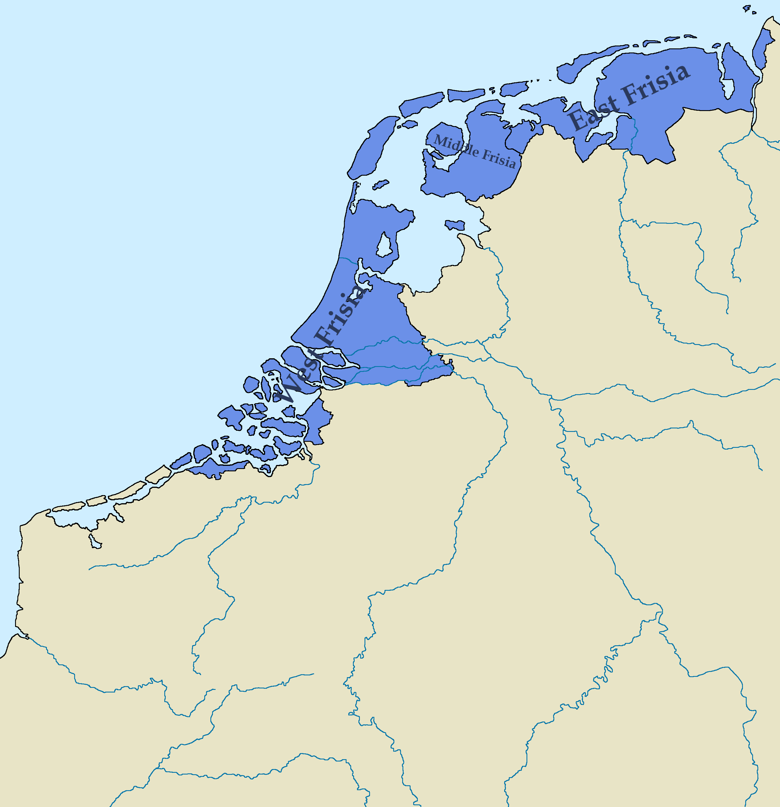
Map Map of the Kingdom of Frisia 600 AD - 734 AD, Based on various sources, combined to try and find the most accurate combination of borders.

Post image
526 Upvotes

r/geography • • 1h ago

Question Why is the German-Swiss border at the city of Konstanz like this? Why isn't the border down the middle of the Rhine?

Post image
• Upvotes

r/geography • • 6h ago

Question Weird world generation glitch in Canada. How does something like this even form?(coordinates: 69.395, -131.424)

Post image
156 Upvotes

They kinda look like fish gills


r/geography • • 6h ago

Map German immigration to Texas 1847 - 1850.

Post image
93 Upvotes

The 1840s in Germany were known as the “hungry forties” due to crop failures, famines, hunger riots, all culminating in the German Revolution of 1848-1849.

Some Germans, particularly middle-class professional Germans who were caught in the middle of the violence erupting between the rich and the poor chose to move to Texas to escape.

The Germans that arrived in Texas were demographically different from most of the people that were arriving in Texas at the time, better educated and more highly skilled. They settled primarily in two locations, Fredericksburg, and New Braunfels.

Upon arrival in Fredericksburg, the private citizens negotiated the Meusebach-Comanche peace treaty with the Penateka Comanche, and neither side ever broke it.

German immigrants were almost universally opposed to slavery and to joining the Confederacy. During the June 1861 statewide vote on secession, most Texans voted in favor, but German-dominated areas voted overwhelmingly against it. Gillespie County, where Fredericksburg is, voted 400 to 17 against secession.


r/geography • • 54m ago

Discussion These two flights are arguably the most geographically isolated routes on Earth.

Post image
• Upvotes

r/geography • • 14h ago

Question Why are tornadoes common in that small region of Australia?

Post image
255 Upvotes

It is oddly specific how that small particular region is way more prone to tornadoes than its surroundings. The coast of Eritrea has a similar situation despite being significantly larger than that bit of Australia


r/geography • • 9h ago

Map How much elevation change is within 20 miles of where people live, by US county: 777 ft for the typical American, 9,251 ft in Nye County, NV

Post image
95 Upvotes

r/geography • • 3h ago

Map [OC] Beck, brook or burn? What Britain calls its streams, valleys and hills, mapped from 75,000 Ordnance Survey place names

Post image
22 Upvotes

r/geography • • 4h ago

Map Indian Ocean Trade on Monsoon Winds

18 Upvotes

r/geography • • 6h ago

Question Are there any landlocked countries that eat a lot of seafood?

28 Upvotes

Obviously coastal or island countries are more likely to have an expansive seafood tradition when compared to landlocked countries, but there are some exceptions.

Argentina, the UK, and Australia are some notable examples of coastal/island countries where seafood doesn’t make up a large proportion of the diet.

Does the reverse exist? Are there any landlocked countries that do eat a lot of seafood?


r/geography • • 3h ago

Map My deerest geography conoisseur, let me introduce you to "Remontez le temps", 'take a trip back in time', aka google map but since the 1950's

Thumbnail remonterletemps.ign.fr
5 Upvotes

All this thanks to cross-referenced and combined aerial photographs
truely amazing for a local


r/geography • • 2h ago

Discussion The Facts about EVERY Country, Territory, State - Pt 2 - Afghanistan

1 Upvotes

Today, I will be presenting the next nation on our list... Afghanistan! (If you dont know what im doing, let me tell you the jist, as a young geographer my goal is to deep dive into every single country, territory and state (Yes the US, and Canada States included) Each area has its own distinct culture and personality so my goal every day until i finish all 434 Entrys on this list is to provide information you might have never knew about this country or territory or state, i hope you enjoy reading and yes its a mountain of text please forgive me!)

Afghanistan - The Graveyard of Empires

Afghanistan is a land of towering mountains, ancient civilizations, legendary trade routes, and a history that has shaped the fate of empires! Officially known as the Islamic Emirate of Afghanistan under its current de facto Taliban government, this landlocked country sits at the crossroads of Central and South Asia. It borders Pakistan, Iran, Turkmenistan, Uzbekistan, Tajikistan, and China, making it a historical bridge between civilizations. Its capital and largest city is Kabul, a bustling city nestled among rugged mountains. Afghanistan covers approximately 652,000 square kilometers (252,000 square miles), and its population is estimated at around 43 million people, although exact figures are uncertain because reliable recent census data are limited.

Afghanistan's Geography still includes some interesting stuff! The Hindu Kush mountain range cuts through much of the country, creating dramatic valleys, high mountain passes, and isolated communities. The northeast contains the narrow Wakhan Corridor, a strip of land extending toward China that separates Pakistan from Tajikistan. In contrast, the southwest contains arid deserts and dry plateaus, while fertile river valleys support farming. Afghanistan experiences hot summers, cold winters, and significant snowfall in mountainous regions. Its natural treasures include the turquoise lakes of Band-e Amir, the historic Minaret of Jam, and deposits of copper, iron ore, natural gas, and precious stones such as lapis lazuli.

Afghanistan's population is a diverse mixture of peoples whose identities reflect centuries of migration, trade, and cultural exchange. The Pashtuns are generally considered the largest ethnic group, followed by the Tajiks, Hazaras, Uzbeks, Turkmens, Baloch, Aimaqs, Nuristanis, and others. Exact percentages are disputed, and Afghanistan has no recent comprehensive census establishing a definitive ethnic breakdown. Its two official languages are Dari, a variety of Persian, and Pashto; Uzbek, Turkmen, Balochi, and numerous other languages are also spoken. Islam is the predominant religion, with most Afghans being Sunni Muslims and a significant minority being Shia Muslims, particularly among the Hazara population. Small religious minority communities also have a long history in the country, although their numbers have become extremely small.

Afghanistan's history stretches back thousands of years, long before the modern country existed. Its territory formed part of ancient civilizations and empires, including the Achaemenid Persian Empire, the conquests of Alexander the Great, the Greco-Bactrian kingdoms, the Kushan Empire, and numerous Buddhist and Islamic cultural centers. The region later became an important crossroads on the Silk Road, linking merchants and travelers between China, India, Persia, and the Mediterranean. In 1747, Ahmad Shah Durrani established a state widely regarded as the foundation of modern Afghanistan. During the nineteenth century, Britain and Russia competed for influence in Central Asia, drawing Afghanistan into the geopolitical rivalry known as the Great Game. Afghanistan gained control over its foreign affairs in 1919 following the Third Anglo-Afghan War. The country later experienced a Soviet invasion in 1979, years of civil war, the Taliban's rise to power in the 1990s, a US-led intervention beginning in 2001, and the Taliban's return to power in 2021. Today, the Taliban governs Afghanistan as the de facto authority, and its rule has brought severe restrictions on women's education, employment, and public life.

Not really the greatest place to live either, as it has one of the lowest HDI, Equal Rights, and Religious Freedom, anywhere in the world. Infact on May 11, 2025 they banned chess for gambling. That's right Anyone who likes chess (Looking at you Levi) are suspended and if caught can be sentenced up to any punishment they see fit (Known as Jungle Law) These punishments can range from house arrest to execution... Yeah Pretty Dark.

One of the country's signature dishes is qabuli palaw, a fragrant rice dish traditionally prepared with meat, carrots, raisins, and spices. Other favorites include mantu, steamed dumplings, and bolani, a stuffed flatbread. Green tea is commonly served to guests, while naan is a staple at many meals. Traditional celebrations may include music, poetry, elaborate clothing, and the national sport of buzkashi, in which skilled horsemen compete to carry a weighted animal carcass toward a goal. Afghanistan also has a long literary tradition, with Persian-language poetry and Pashto oral storytelling playing important roles in cultural life. Family, community, and hospitality are central values for many Afghans, although customs vary significantly between regions and communities.

For travel... The Blue Mosque in Mazar-i-Sharif is celebrated for its brilliant blue tilework; Band-e Amir is known for its striking blue lakes; and Herat contains centuries-old Islamic architecture. The Minaret of Jam, a UNESCO World Heritage Site, stands as an extraordinary example of medieval architecture in a remote mountain valley. However, there is a crucial distinction between a country's tourism potential and the safety of visiting it. As of October 2026, the US State Department's published advisory is Level 4: Do Not Travel, citing serious risks including terrorism, kidnapping, wrongful detention, and limited consular assistance. Afghanistan's cultural heritage is fascinating, but visiting is not currently a safe choice for ordinary travelers. So best not to walk into Afghanistan.

Afghanistan is far more than a country associated with war in the headlines. It is a land of ancient empires, extraordinary mountain landscapes, diverse ethnic communities, deep religious traditions, and cultural treasures that connect civilizations across Asia. Yet its modern history also reflects the devastating consequences of invasion, conflict, economic hardship, and political repression. To understand Afghanistan properly, we must recognize both its remarkable heritage and the struggles faced by its people today.

If you want to deep dive yourself, check out Geography Now - Afghanistan, Brittanica - Afghanistan or UNESCO to dive deeper! I highly recommend watching and reading these!

Tell me if i missed anything, thank you for reading and have a blessed day!

Next stop: Akrotiri!


r/geography • • 1d ago

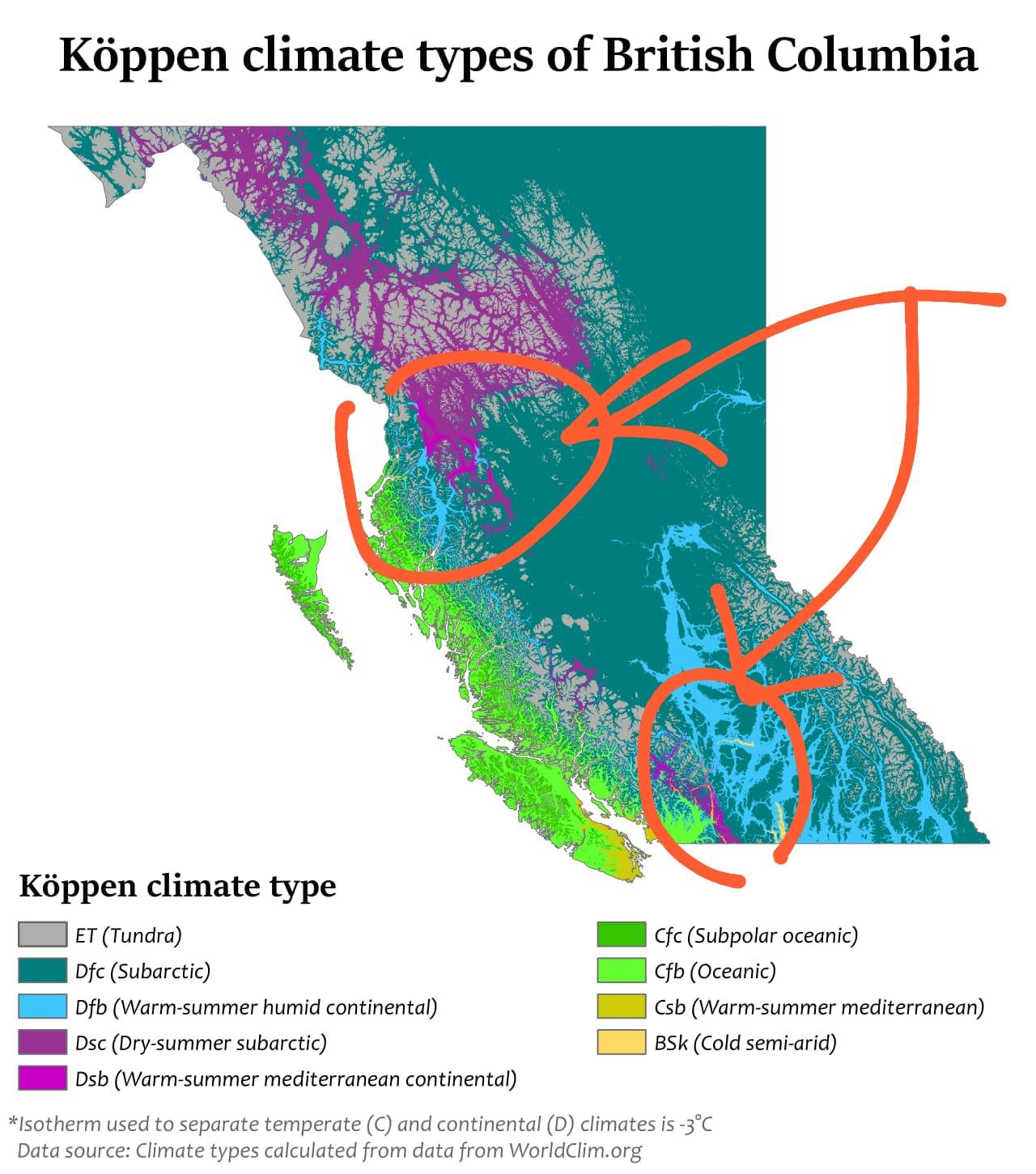
Question How livable are these parts of Canada, where Dsb climates are surrounded by ET and Dfc climates? I'm curious about what life is actually like in these areas, especially in terms of weather, accessibility, and overall quality of life

Post image
193 Upvotes

r/geography • • 1d ago

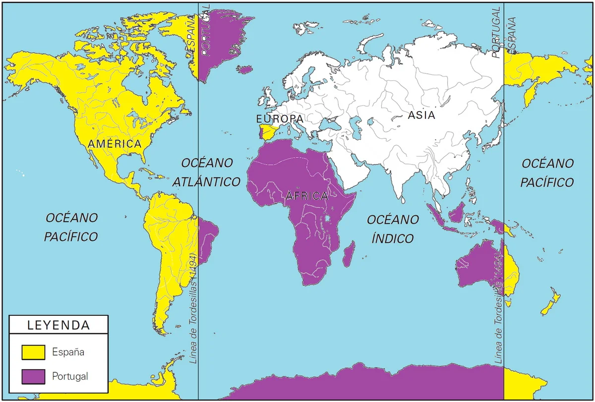
Question Is the Treaty of Tordesilhas responsible for the split in New Guinea or is it just a coincidence that the country's been split vertically around the same area as the treaty would split it?

Post image
733 Upvotes

r/geography • • 1d ago

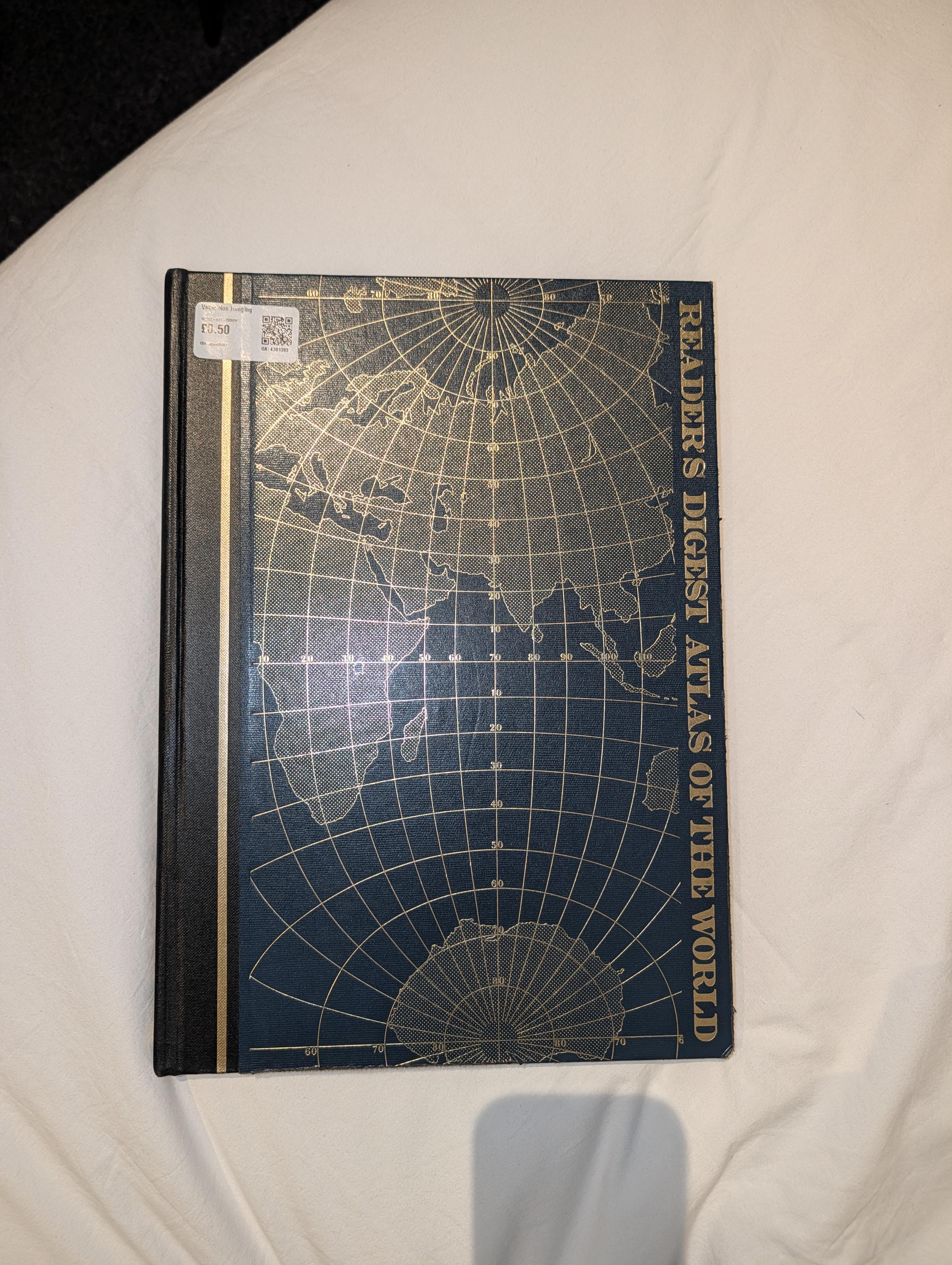
Image Bought this beautiful old atlas from a charity shop for 50p

Post image
60 Upvotes

It's from 1987 and it's really big! Just thought I'd share for fellow enthusiasts :)


r/geography • • 1d ago

Question What's up with these islands in Nunavut? Why are they shaped like this?

Post image
282 Upvotes

r/geography • • 1h ago

Question Is it a feasible idea to enclose and drain Sea of Azov(Average depth 7m), and use it as massive arable land?

Post image
• Upvotes

Yeah I know, Don and probably some other rivers gonna have to be diverted(or canaled), and it's effect on the rest of the Black Sea is gonna have to be thought out, but I don't really sea why we can't do it other than maybe that it's going to slightly effect marine ecology of Black Sea.

Or.... possibly overflow the Black Sea? IDK! You are probably more expert than I!


r/geography • • 2d ago

Question How does India remain united?

Post image
1.7k Upvotes

India is home to hundreds of languages and ethnic groups. Not to mention, multiple predominant religions (Dharmic religions, Islam, Christianity is some spots). I’ve heard of turmoil between Indian Muslims and Hindus but I’m not too sure of the impact it’s had on the security of the country as a whole. With so many languages and ethnic groups, how does this dynamic play out? How do Indian people remain so seemingly united as one “Indian” population?

Want to acknowledge that I’m exposed to western media that usually doesn’t cover Indian news and politics.

EDIT: was just informed this map is a bit inaccurate! This website is more reputable and has a cool map feature...

https://clearglobal.org/resources/language-data-for-india/


r/geography • • 2d ago

Discussion Would you say Brazil is the most famous example where its capital city, its most populated city and its most famous city are all 3 different cities?

2.0k Upvotes

The capital city of Brazil is Brasilia, its most populated city is Sao Paulo and its most famous city is Rio de Janeiro. Usually in countries whose capital isn't their most populated city, their most populated city is also its most famous.

For example the capital city of United States is Washington DC but New York is both its most populated and most famous city.

The capital city of Australia is Canberra but Sydney is both its most populated and most famous city


r/geography • • 1d ago

Image The Hankinson Sandhills - Richland county, North Dakota

Post image
142 Upvotes

Like the dune fields adjascent to the modern Sheyenne River, the Hankinson Sandhills are the result of glacial meltwater runoff. Particularly, the fine deltaic sands that make up the soil substrate here is the result of the drainage of Glacial Lake Milnor, which represented the highest stage of Lake Agassiz as a whole. As such, the Sheyenne Delta dune fields west of Colfax are a younger version of the exact same process.

These dunes are essentially an older, southern expression of the Sheyenne Delta - a result of the drainage of Lake Milnor by the ancestral Sheyenne that once found its outlet near Hankinson. As the outlet of the ancient Sheyenne migrated north along its historic delta over time, shifting with the fluctuating water levels, the much larger complex of dunes was later formed to the north.

Eolian in origin, those fine sands were sculpted by the wind into the nearly alien topography we see today on both ends of the Delta. The Hankinson Sandhills are however much more isolated than the northern complex, and hosts overall slightly lower plant biodiversity, but otherwise mirrors the Sheyenne Grasslands dune fields.

However, these permeable sands do serve as one of the primary areas of surficial aquifer recharge area wide aside from the end moraines to the SW. An ecological island, and also serves a very important role in groundwater recharge.

I highly recommend everyone to visit here to at least explore this strange topography if nothing else!


r/geography • • 1d ago

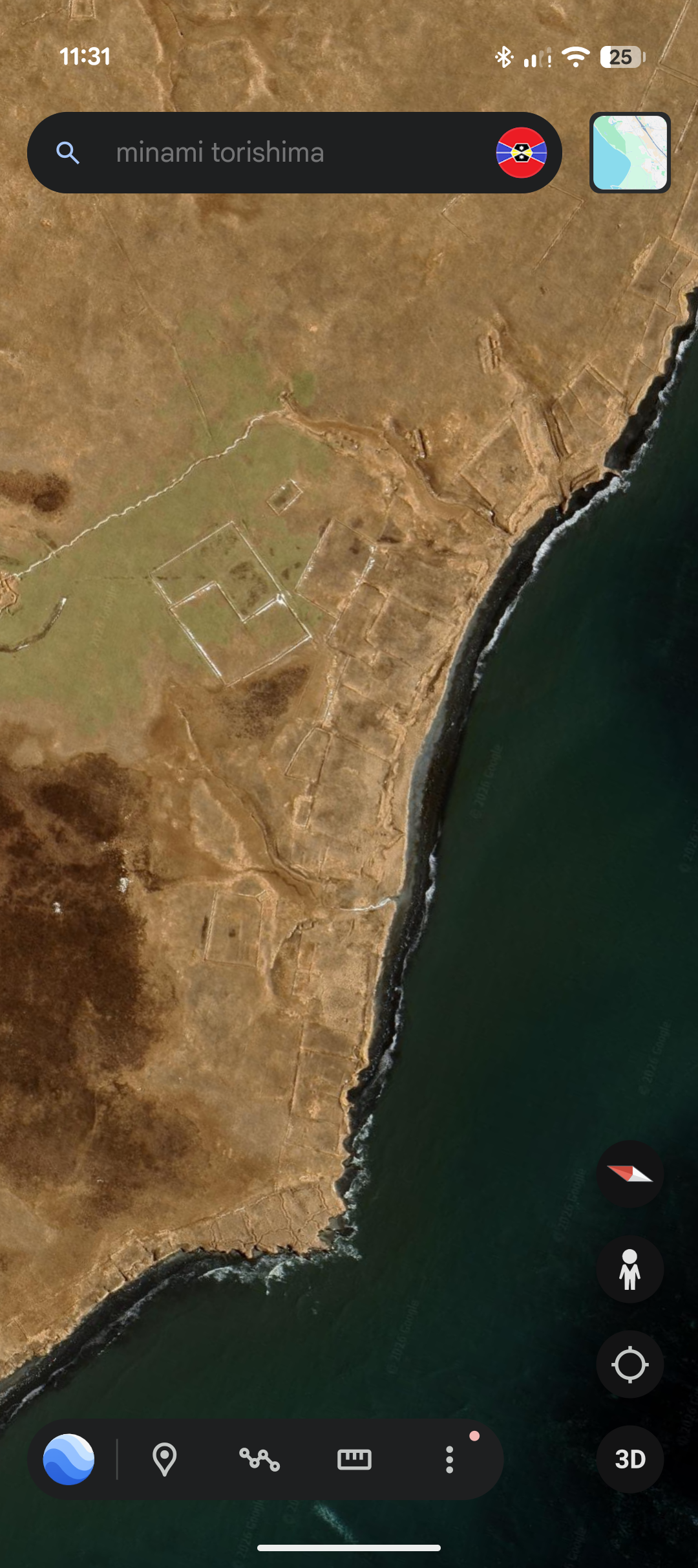
Question Interesting Shapes on an Island in South-Eastern Russia, just north of Hokkaido, does anyone know what they are?

Post image
39 Upvotes

The island isn't named on Google Earth, so I can't provide a name, nor does this sub allow more than 1 image, so here's the coordinates: 43°37'21.89"N 146°20'25.24"E

Aside from these shapes, there's an abandoned (most likely) Soviet base from WWII, though I can't say for certain if it's actually theirs or if any other details are true.

What really caught my eye was the circular shape just out of frame, it kinda looks cool, not much else.

I'm intrigued by old structures like those from times now gone, and would love to know what they are, so I could look at photographs if it existed during that time period.

This is also my first post in this sub, I wanted to post this in the Archaeology sub but they had rules against possible ancient locations being looted, but I highly doubt this place holds anything valuable. If there is an issue with this post being here, please recommend a valid place to post this, and I shall scoot over there. Thanks for reading!


r/geography • • 1d ago

Question How does Salinas, Ecuador and the rest of the surrounding area manage to be so lush despite being a BWh climate?

Post image
29 Upvotes

In this photo, the climate is considered a hot arid climate (80-130mm rain a year) but it manages to be lush with actual tree and grass cover, which does not fit the picture most would have in mind for a desert climate.


r/geography • • 2d ago

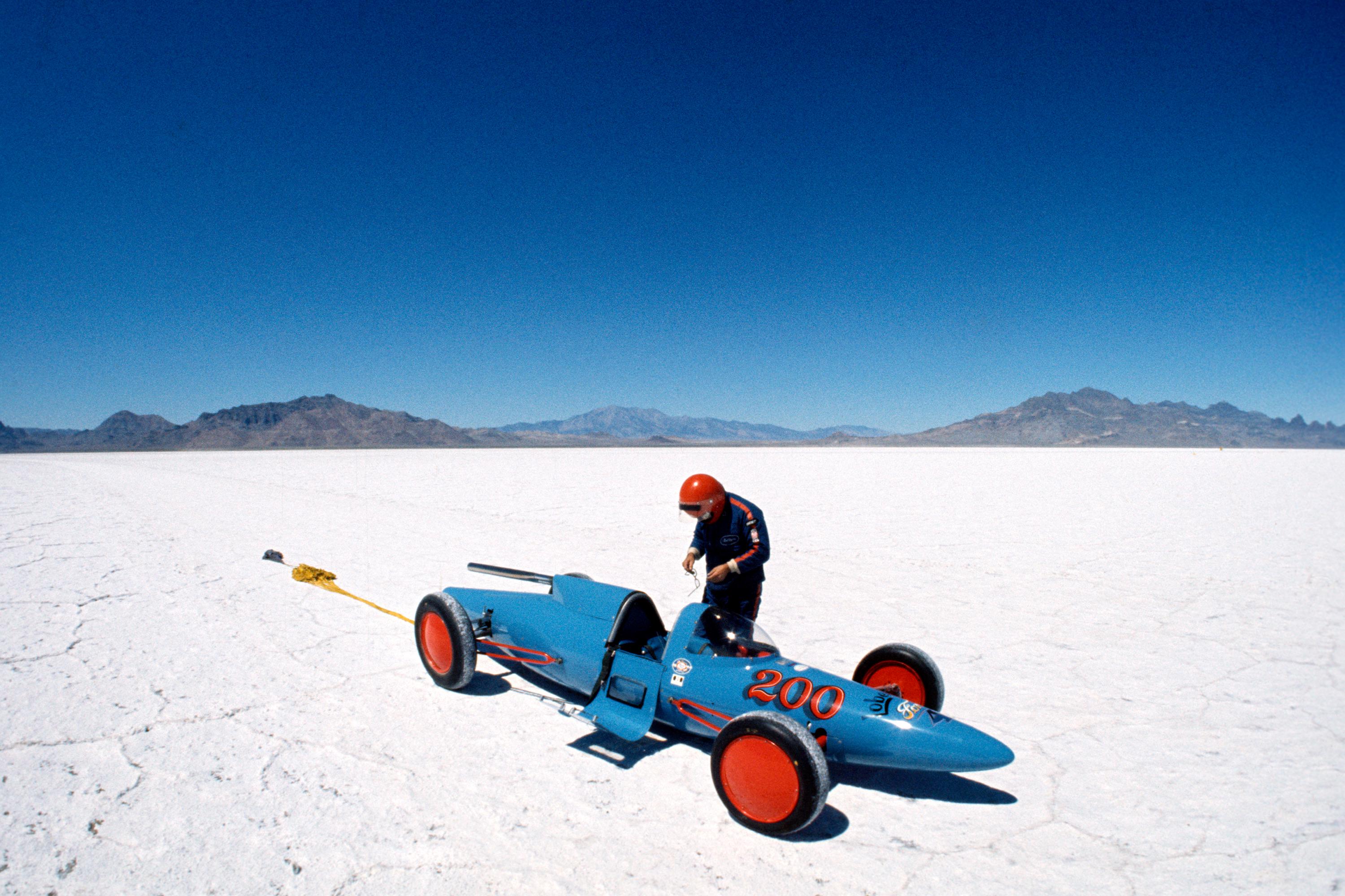
Image Bonneville Salt Flats - Tooele County, Utah.

Post image
26 Upvotes

Just North of I-80 between Salt Lake City, UT, and Reno, NV is the Bonneville Salt Flats, home of the world-famous Bonneville Speedway.

First popularized as a place for attempting land-speed records by David Abbot “Ab” Jenkins in the 1930s, it eventually replaced Daytona Beach and Monthlhéry track in France as the preeminent spot to attempt land-speed records. But Bonneville lost its spot as the place where the absolute land-speed record got set with the current record-holder, Thrust SSC, in 1997 because of too much damage to the salt surface and limited space. The Black Rock Desert in Nevada is where the current land-speed record was set.

Every year from late June through September various different motor-sport organizations hold events at the Bonneville Speedway such as Speed Week in early August and World of Speed in early September.