r/geography • u/Party_Kangaroo_3300 • 4h ago
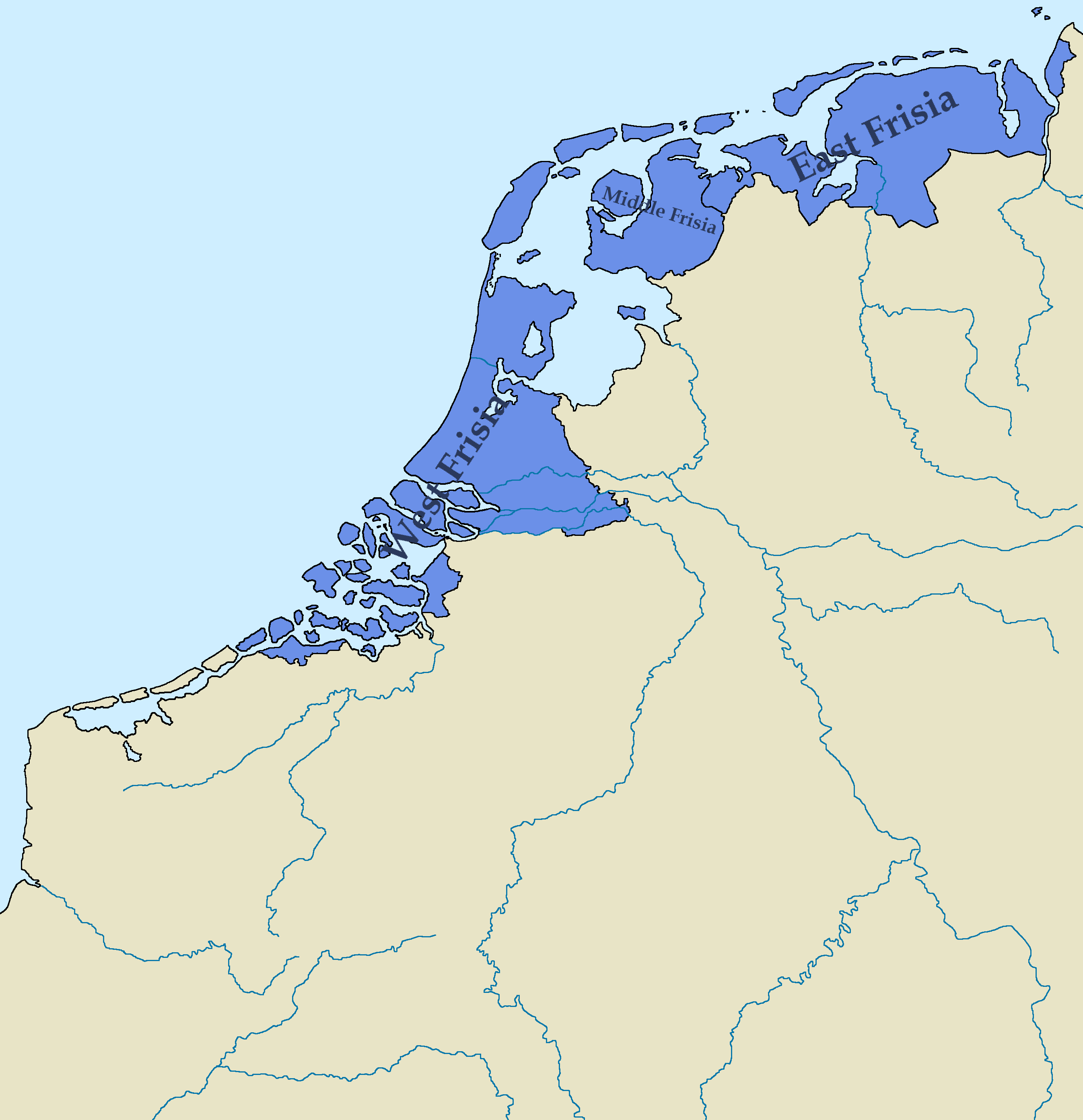
Map Map of the Kingdom of Frisia 600 AD - 734 AD, Based on various sources, combined to try and find the most accurate combination of borders.
417
Upvotes
r/geography • u/Party_Kangaroo_3300 • 4h ago
r/geography • u/MediumStrange • 9h ago
The Upper Pensula and Northwoods, Adirondacks and northern New England, the Ohio valley and Appalachia. All of these places are commonly said to have the best fall colors in the country, and those regions are also where the highest density of sugar maples are.
One of the best trees in the world, simply stunning in fall.
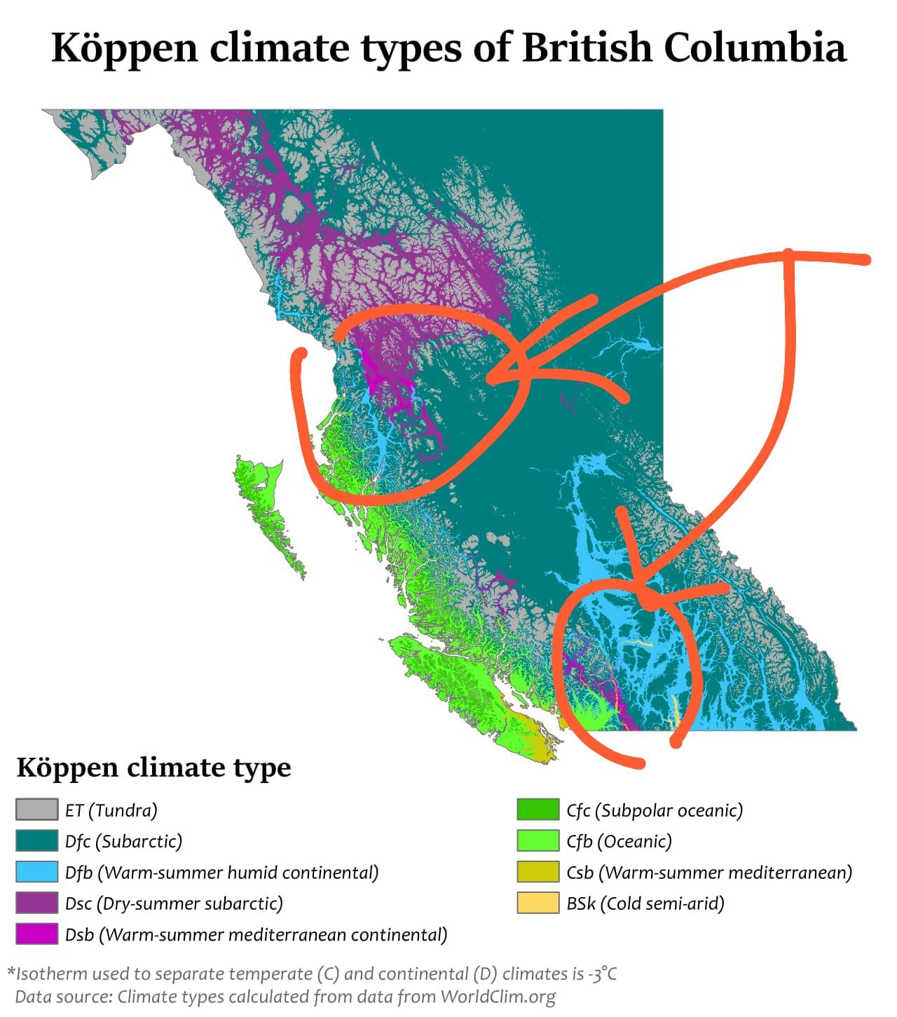
r/geography • u/Naomi62625 • 11h ago
It is oddly specific how that small particular region is way more prone to tornadoes than its surroundings. The coast of Eritrea has a similar situation despite being significantly larger than that bit of Australia
r/geography • u/MeatloafIsPrettyGood • 4h ago
They kinda look like fish gills
r/geography • u/Old_Tomato_214 • 6h ago
r/geography • u/2001_Arabian_Nights • 3h ago
The 1840s in Germany were known as the “hungry forties” due to crop failures, famines, hunger riots, all culminating in the German Revolution of 1848-1849.
Some Germans, particularly middle-class professional Germans who were caught in the middle of the violence erupting between the rich and the poor chose to move to Texas to escape.
The Germans that arrived in Texas were demographically different from most of the people that were arriving in Texas at the time, better educated and more highly skilled. They settled primarily in two locations, Fredericksburg, and New Braunfels.
Upon arrival in Fredericksburg, the private citizens negotiated the Meusebach-Comanche peace treaty with the Penateka Comanche, and neither side ever broke it.
German immigrants were almost universally opposed to slavery and to joining the Confederacy. During the June 1861 statewide vote on secession, most Texans voted in favor, but German-dominated areas voted overwhelmingly against it. Gillespie County, where Fredericksburg is, voted 400 to 17 against secession.
r/geography • u/Zest_Leader • 18m ago
r/geography • u/TrixoftheTrade • 3h ago
Obviously coastal or island countries are more likely to have an expansive seafood tradition when compared to landlocked countries, but there are some exceptions.
Argentina, the UK, and Australia are some notable examples of coastal/island countries where seafood doesn’t make up a large proportion of the diet.
Does the reverse exist? Are there any landlocked countries that do eat a lot of seafood?
r/geography • u/Skelat • 21m ago
All this thanks to cross-referenced and combined aerial photographs
truely amazing for a local
r/geography • u/EzamArya • 1d ago
r/geography • u/geosunsetmoth • 1d ago
r/geography • u/Fun-Ad-2547 • 1d ago
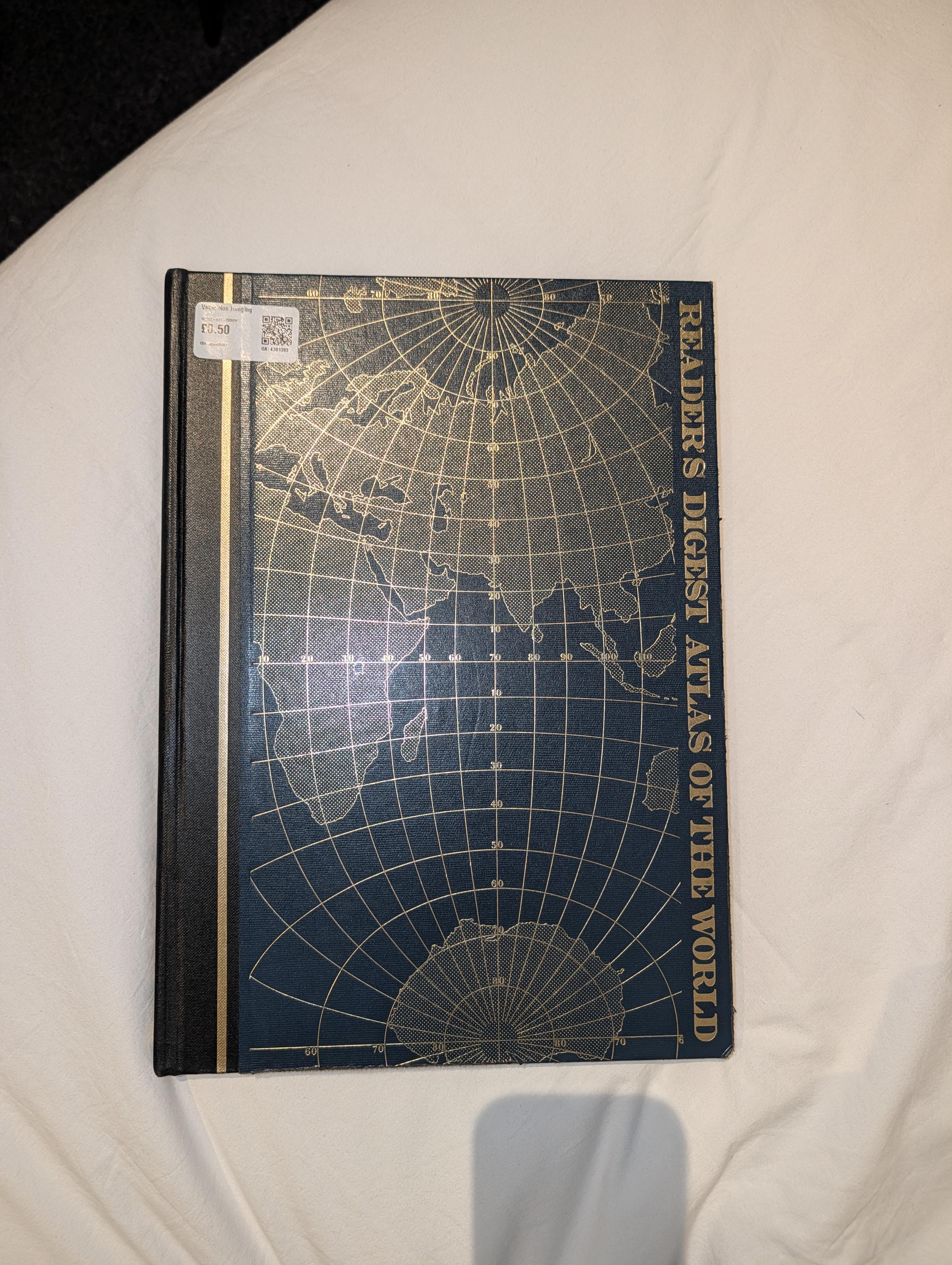
It's from 1987 and it's really big! Just thought I'd share for fellow enthusiasts :)
r/geography • u/The_Maxinator0612 • 1d ago
r/geography • u/tmmhs05 • 50m ago
Μόλις συνειδητοποίησα ότι ο ήλιος ανατέλλει από την ΑΝΑΤΟΛΉ και δύει από τη ΔΥΣΗ
Δεν είχα κάνει ποτέ αυτή τη σύνδεση, το πήγαινα μόνο με βάση τη σημασία των λέξεων...🫠🙃
r/geography • u/barrydingl • 2d ago
India is home to hundreds of languages and ethnic groups. Not to mention, multiple predominant religions (Dharmic religions, Islam, Christianity is some spots). I’ve heard of turmoil between Indian Muslims and Hindus but I’m not too sure of the impact it’s had on the security of the country as a whole. With so many languages and ethnic groups, how does this dynamic play out? How do Indian people remain so seemingly united as one “Indian” population?
Want to acknowledge that I’m exposed to western media that usually doesn’t cover Indian news and politics.
EDIT: was just informed this map is a bit inaccurate! This website is more reputable and has a cool map feature...
r/geography • u/LowInteraction6397 • 2d ago
The capital city of Brazil is Brasilia, its most populated city is Sao Paulo and its most famous city is Rio de Janeiro. Usually in countries whose capital isn't their most populated city, their most populated city is also its most famous.
For example the capital city of United States is Washington DC but New York is both its most populated and most famous city.
The capital city of Australia is Canberra but Sydney is both its most populated and most famous city
r/geography • u/KagamiRyuunosuke • 1d ago
Like the dune fields adjascent to the modern Sheyenne River, the Hankinson Sandhills are the result of glacial meltwater runoff. Particularly, the fine deltaic sands that make up the soil substrate here is the result of the drainage of Glacial Lake Milnor, which represented the highest stage of Lake Agassiz as a whole. As such, the Sheyenne Delta dune fields west of Colfax are a younger version of the exact same process.
These dunes are essentially an older, southern expression of the Sheyenne Delta - a result of the drainage of Lake Milnor by the ancestral Sheyenne that once found its outlet near Hankinson. As the outlet of the ancient Sheyenne migrated north along its historic delta over time, shifting with the fluctuating water levels, the much larger complex of dunes was later formed to the north.
Eolian in origin, those fine sands were sculpted by the wind into the nearly alien topography we see today on both ends of the Delta. The Hankinson Sandhills are however much more isolated than the northern complex, and hosts overall slightly lower plant biodiversity, but otherwise mirrors the Sheyenne Grasslands dune fields.
However, these permeable sands do serve as one of the primary areas of surficial aquifer recharge area wide aside from the end moraines to the SW. An ecological island, and also serves a very important role in groundwater recharge.
I highly recommend everyone to visit here to at least explore this strange topography if nothing else!
r/geography • u/CanadaGiver • 1d ago
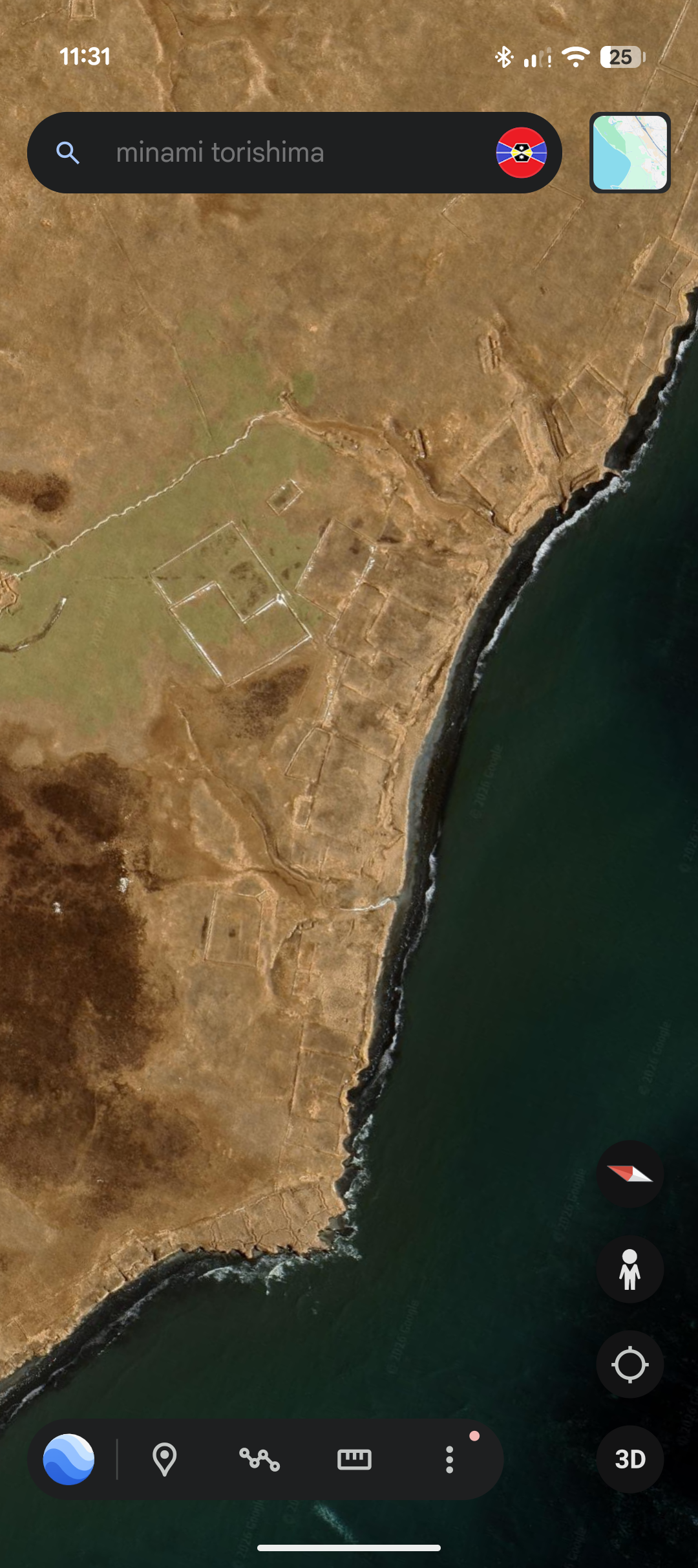
The island isn't named on Google Earth, so I can't provide a name, nor does this sub allow more than 1 image, so here's the coordinates: 43°37'21.89"N 146°20'25.24"E
Aside from these shapes, there's an abandoned (most likely) Soviet base from WWII, though I can't say for certain if it's actually theirs or if any other details are true.
What really caught my eye was the circular shape just out of frame, it kinda looks cool, not much else.
I'm intrigued by old structures like those from times now gone, and would love to know what they are, so I could look at photographs if it existed during that time period.
This is also my first post in this sub, I wanted to post this in the Archaeology sub but they had rules against possible ancient locations being looted, but I highly doubt this place holds anything valuable. If there is an issue with this post being here, please recommend a valid place to post this, and I shall scoot over there. Thanks for reading!
r/geography • u/HonestLemon25 • 1d ago
In this photo, the climate is considered a hot arid climate (80-130mm rain a year) but it manages to be lush with actual tree and grass cover, which does not fit the picture most would have in mind for a desert climate.
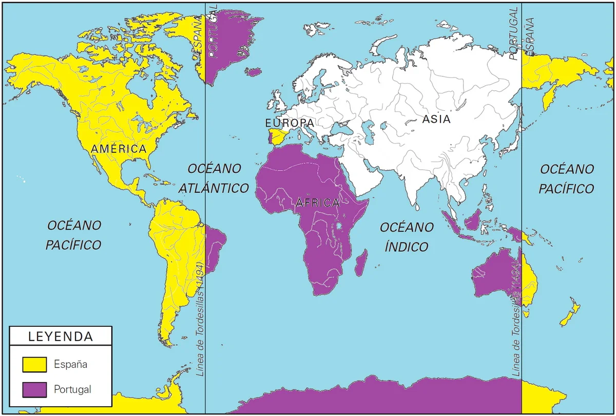
r/geography • u/2001_Arabian_Nights • 1d ago
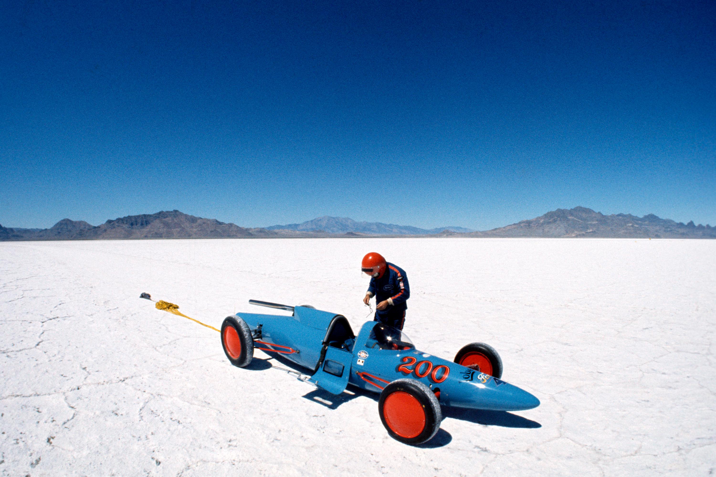
Just North of I-80 between Salt Lake City, UT, and Reno, NV is the Bonneville Salt Flats, home of the world-famous Bonneville Speedway.
First popularized as a place for attempting land-speed records by David Abbot “Ab” Jenkins in the 1930s, it eventually replaced Daytona Beach and Monthlhéry track in France as the preeminent spot to attempt land-speed records. But Bonneville lost its spot as the place where the absolute land-speed record got set with the current record-holder, Thrust SSC, in 1997 because of too much damage to the salt surface and limited space. The Black Rock Desert in Nevada is where the current land-speed record was set.
Every year from late June through September various different motor-sport organizations hold events at the Bonneville Speedway such as Speed Week in early August and World of Speed in early September.
r/geography • u/thlucena • 2d ago
I live in Northeastern Brazilian coast. Since I like hot weather and sunny days, the climate here is almost perfect to me. The temperature is never above 31°C and never below 21°C, never. Most of the days are sunny with temperature ranging between 24°C and 30°C.
I have been wondering: if the mean, min and max temperatures were ~3°C less, guess that would be the definitive perfect weather for me.
So, is there any place in the world like that all year long? With plenty of sunny days, a max of 27°C and min of 20°C, and never going past those limits?
r/geography • u/rra122508 • 1d ago
r/geography • u/Gillopy • 2d ago
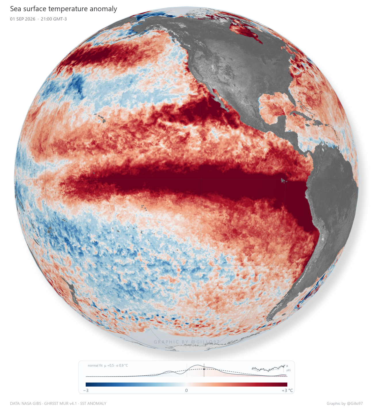
I’m sharing a couple of images showing how sea surface temperature anomalies in the equatorial Pacific intensified over time — a phenomenon linked to the torrential rainfall and massive hailstones we experienced.
Time-lapse 👉🏻 https://www.youtube.com/shorts/Y681RKt08kQ
r/geography • u/TheGMan43 • 1d ago
Back in the day I used to have an app where you could select a continent or the whole world, and just try and name every country. The map had country outlines on and coloured them in so you could see what you were missing.
Does anyone know what it could be, or a similar app? I'm not looking for anything extra, just want to try looking at an unlabelled map and label it.
TIA!